
Follow Us on Facebook!
INTRODUCING THE 2025 - 2026 MBGS EXECUTIVE COMMITTEE MEMBERS
-
President: Andrea Munoz-Hernandez, Ph.D., GISP. Mich. Dept. of Environment, Great Lakes and Energy
-
Vice President: vacant
-
Secretary: John Yellich, Michigan Geological Survey
-
Treasurer : Peter Rose Michigan Department of Natural Resources
-
Business Manager: Peter Rose, Michigan Department of Natural Resources
-
Past President: Jennifer Trout, Michigan Geological Survey
-
Newsletter Editor: Arlene Anderson-Vincent, Blue Triton Brands
-
Webmaster: John Esch, Michigan Geological Survey
-
Interim Field Trip Directors: John Esch & Chris Christensen
MBGS has monthly meetings typically on the 2nd Wednesday
of each month from September - May
ACCEPTING APPLICATIONS FOR THE 2027 MBGS E.Z. MANOS MEMORIAL SCHOLARSHIP
Michigan Basin Geological Society will award two scholarships up to $500 each to students conducting graduate or undergraduate research in geology related to Michigan. The scholarships will be awarded at an upcoming MBGS meeting and the winner(s) will be notified In December. We hope recipients can attend a spring MBGS meeting to present their research topic. Candidates should complete and submit the MBGS scholarship application form by December 20, 2026 to John A. Yellich, MBGS Secretary, at jasty98@aol.com with subject Line: MBGS Scholarship 2027. Applications can be found on MBGS’s Scholarship Page
OTHER NEWS: MBGS HISTORICAL PUBLICATIONS ARE NOW AVAILABLE ON USB FLASH DRIVES (8GB).
MBGS Publications ‐ There are two (2) new publications available! See details on the Publications page
MBGS On-line Store - Shop for shirts, hats, bags and other items. Check it out at: http://www.cafepress.com/mbgs
MBGS MEMBERSHIP DUES
MBGS continues to strive to provide a platform for geologist and environmental professionals to connect and offer learning and field trip opportunities. For 2025-2026, our annual dues are $35. Student Membership is free. Email any one of our officers if you are a student and would like to be a member. We now offer the option to renew your professional membership via PayPal. Please refer to the renewal notices that are included in the newsletter. Student Membership is free.
Professional Membership Dues

Opportunity for Members: MBGS is seeking members who are interested in getting involved. We need a Vice President, Treasurer, and a Secretary for the 2025-2026 year. If you are interested in these opportunities, please reach out to any of the executive committee members.
Opportunity for Presenters: MBGS is seeking presenters for Michigan Basin geologically-related topics for our 2025-2026 membership meetings. If interested, please contact Andrea Muno-Hernandez at munozhernandeza@michigan.gov.
Next Meeting
Please join us for the Michigan Basin Geological Society’s membership meetings for the 2025-2026
MBGS free membership meeting on Tuesday May 12 Social: 6:45 PM
Presentation: 7:00-8:00 PM
East Lansing Public Library
950 Abbot Rd, East Lansing,
Michigan 48823
Speaker: Reece P. Elling, PhD
Grand Valley State University
Affiliate Professor of Geology
Website: bit.ly/reeceelling
Topic: Rift Evolution and Precambrian Tectonics: Insights from North America’s Failed Midcontinent Rift
ABSTRACT:
Failed continental rifts provide unique opportunities to study aspects of plate tectonic evolution frozen in time. North America contains three major failed rifts: The Midcontinent Rift (MCR), Southern Oklahoma Aulacogen (SOA), and the Reelfoot Rift (RR). To understand why some rifts fail while others succeed to seafloor spreading, this work explores details of these rifts and their interactions within the framework of Laurentia’s tectonic history.
Although the ~1100 Ma MCR is exposed along Lake Superior, it is primarily delineated by gravity, magnetic, and seismic data through the central United States. Its structures and evolution, defined by gravity modeling, seismic, and geologic data, tell a story of a sequence of extension, volcanism, subsidence, sedimentation, and subsequent inversion. Near the MCR’s eastern arm also lie orogenic facies related to the Grenville Orogeny, a series of discrete collisions between Laurentia and Amazonia that culminated in the assembly of the supercontinent of Rodinia. Examining the interaction of these juxtaposing tectonic events using their gravity signatures revealed that the lineated gravity highs in the eastern U.S. appear similar to those along the remainder of the MCR, and unlike those along any portion of the Grenville Front (GF) where it is exposed and identified by seismic and potential field data in Canada. However, thrust sheet structures, like those of the southern Canadian GF, are likely present along the MCR’s east arm, as implied by recent seismic data.
Investigating the similarities and differences of North America’s three major failed rifts – the MCR, SOA, and RR – provide insight into the rifting process. All three rifts formed in similar tectonic settings as part of Laurentia’s interactions within Rodinia, and followed similar evolutionary paths of extension, magmatism, subsidence, and inversion by later compression, leading to similar widths and architecture. However, differences between the rifts reflect the extent to which these processes occurred. Because no sea floor older than a few hundred million years exists, understanding the tectonics of the Precambrian requires the use of paleomagnetic data to constrain plate motions and model global tectonics. Part of this research involved compiling over 15,000 published paleomagnetic poles to support a 1.5 Ga global plate model that was used to investigate the correlation between cusps in apparent polar wander paths and major tectonic events (such as rifting). This approach can be useful in defining tectonic events in time periods during which paleomagnetic data may be the only constraints.
BIOGRAPHY:
Since graduating from GVSU in 2016, Reece completed a PhD in Geophysics at Northwestern University where he researched failed continental rifting events to understand their possible evolution paths in succeeding, or failing to succeed, to volcanic passive margins. He primarily focused on North America’s Midcontinent Rift, and interpreted gravity, magnetic, and seismic data from the surrounding region to build subsurface models to understand its formation. While wrapping up his dissertation, he interned with the geophysical applications group at ExxonMobil, but Reece kept being drawn back to his passion for teaching. After graduating, he taught for one year at Indiana University Northwest before returning to GVSU as an Affiliate Faculty in 2023, where he’s had the opportunity to teach introductory geology courses alongside solid earth materials, structural geology, and geophysics. He is currently mentoring several undergraduate research projects investigating the youngest bedrock in the Michigan Basin - the red beds of Ionia. Outside of work, Reece lives in Spring Lake with his wife, Hayley, and daughter, Inez, where they spend as much time as possible hiking in the dunes along Lake Michigan.
RELATED RECENT PUBLICATONS:
Elling, R.P., Stein, S., Gefeke, K., Stein, C.A., 2022. North America’s Three Rifts: Similarities and
Differences. GSA Today, v. 32, 8 pp.
Stein, C.A., Stein, S., Gallahue, M., Elling, R.P., 2021. Revisiting hotspots and continental breakup –
Updating the classical three-arm model, GSA Special Paper “In the Footsteps of Warren B. Hamilton: New Ideas in Earth Science”, v. 553, p. 1-17.
Elling, R.P., Stein, S., Stein, C.A., Keller, G.R., 2019. Tectonic implications of the gravity signatures of
the Midcontinent Rift and Grenville Front. Tectonophysics.
Stein, S., Stein, C.A., Elling, R.P., Kley, J., Keller, R., Wysession, M., Rooney, T., Frederiksen, A., and
Moucha, R., 2018. Insights from North America’s failed Midcontinent Rift into the evolution of continental rifts and passive continental margins. Tectonophysics. v. 744, p. 403-421.
Stein, C.A., Stein, S., Elling, R.P., Keller, G.R., and Kley, J., 2018. Is the “Grenville Front” in the central
United States really the Midcontinent Rift? GSA Today, v. 28(5), p. 4-10.
Go to Presentations page for recent MBGS presentations as PDF files
Below are links to recordings of the past (3) MBGS meetings
A 3-D Bedrock Geologic and Hydrostratigraphic Model of Southern Ontario
Date: April 13th, 2022
Meeting Recording:
Below are the 2 original presentations that Terry presented:
A Revised 3-D Geologic Model of the Bedrock of Southern Ontario and Progress on Development of a 3-D Hydrostratigraphic Model
https://www.youtube.com/watch?v=H0VZLNMxpKU&list=PLdapv5BeduhV3JoX6F4giIHGRgYI6Bkag&index=2
A 3-D Bedrock Hydrostratigraphic Model of Southern Ontario
https://www.youtube.com/watch?v=GgJmOHYZtak&list=PLdapv5BeduhXJZedclmAYiccOCcSuYsMW&index=20
Articles referenced in the presentation:
A Hydrostratigraphic Framework for the Paleozoic Bedrock of Southern Ontario
https://journals.lib.unb.ca/index.php/GC/article/view/31465/1882527052
A Three-Dimensional Geological Model of the Paleozoic Bedrock of Southern Ontario, Groundwater Resources Study 19 Geological Survey of Canada, Open File 8618
http://www.geologyontario.mndm.gov.on.ca/mndmfiles/pub/data/imaging/GRS019//GRS019_Report.pdf
Lake Michigan Shorelines, Catastrophic Failure or Stable, That is the Question, Date: Jan 12, 2022
Meeting Recording:
https://us06web.zoom.us/rec/share/-Gr3efOHXLqk_SSFJqsMG9VpAk8sbQc9WWZDroawji1DYfjnD84IfzTSsc3XYh78.zXGywtGcpy1j0c_B
Grand Canyon MBGS Field Excursions, Date: Feb 9, 2022
Meeting Recording:

Geology in the News
New Survey Publication – An Updated Bibliography of Michigan Geology
John Yellich and Peter Voice, Western Michigan University Department of Geological Sciences and Michigan Geological Survey
The Michigan Geological Survey is proud to announce a new publication: Michigan Geology: A Bibliography, the second volume in the Michigan Geological Survey Data Compilation Series. This updated compilation lists over 7,700 references from all known Michigan sources, including industry, professional associations and universities and includes publications from 1818 to present. This report documents 200 years of Geological Research in Michigan. The Bibliography is sorted into four general categories – Precambrian, Basin, Quaternary, and Other.
This updated version of the bibliography also includes a short section on Michigan Stratigraphic Nomenclature, as well as brief discussion of historical trends in publication frequency in Michigan.
The report is free to download at the Michigan Geological Survey’s webpage: https://wmich.edu/geologysurvey/research/publications.

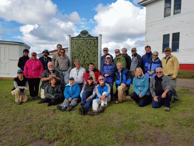
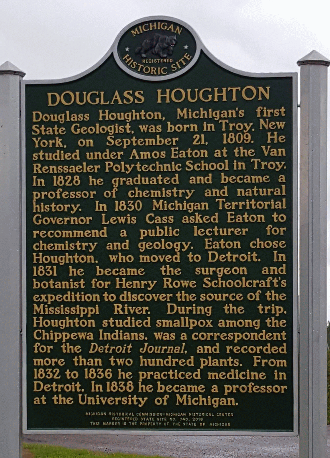
DOUGLASS HOUGHTON MEMORIAL
Douglass Houghton, Michigan’s first State Geologist, was honored on September 10, 2016 by
the placement of a State of Michigan Historical Marker commemorating his accomplishments. The
effort was led by Arlene Anderson‐Vincent, members of the Michigan Basin Geological Society,
Keweenaw County Historical Society and faculty at Western Michigan University and Michigan
Technological University. The dedication was incorporated into a MBGS field excursion led by
Professor Ted Bornhorst of Michigan Technological University and Lawrence Molloy, President of the Keweenaw County Historical Society. The two led a field excursion that covered the geology and history of sites from Houghton to Copper Harbor and wove a tale of the rise and fall of mining in the copper range. The field excursion included the dedication of the marker, which is located in Eagle River, Michigan at the Keweenaw County Historical Museum. The dedication had many speakers and a special appearance from Kyle Bagnall, who portrayed Bela Hubbard who told the story of Douglass Houghton’s 1840 expedition along Lake Superior. Douglass Houghton died in 1845 when the boat carrying himself and his crew capsized during a storm on Lake Superior near Eagle River.
Michigan Basin Geological Society


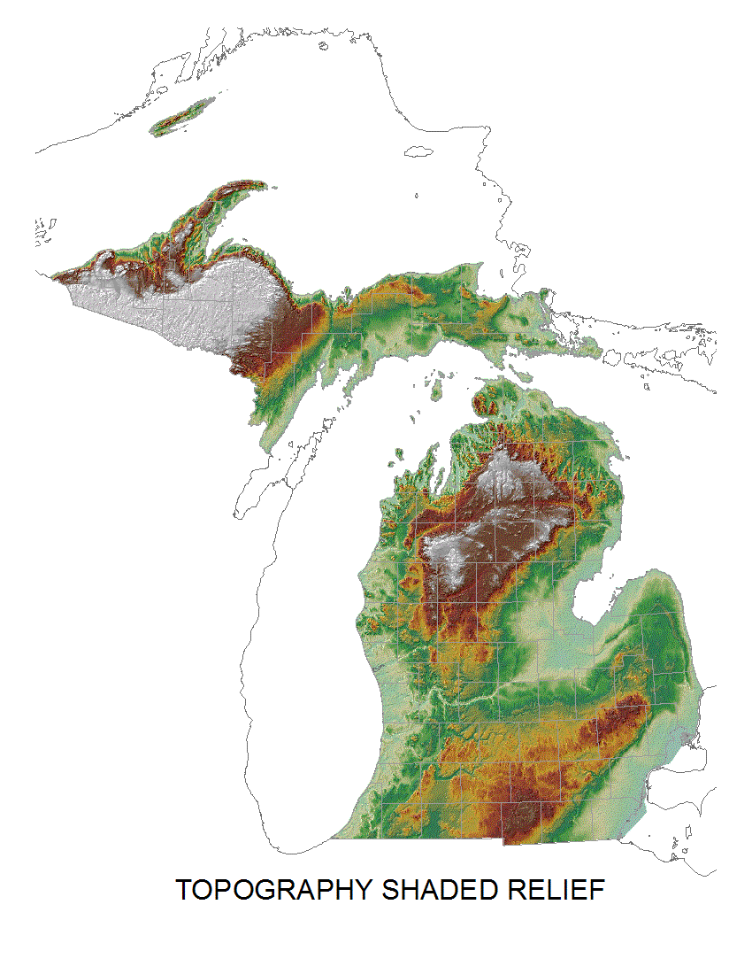
The Michigan Basin Geological Society (MBGS) was founded in 1936 as an affiliated non-profit organization of the American Association of Petroleum Geologists (AAPG) to provide a forum for the exchange of ideas relating to the field of petroleum geology through field excursions and meetings.
Throughout the years, the role of the society has changed, and both meetings and field excursions now address a wide range of topics pertaining to the study of geology of Michigan and the great lakes area, and is open to anyone interested in geology.
MBGS has monthly meetings typically on the second Wednesday of each month from September through May. These meeting consist of a lecture on a wide variety of Michigan geology related topics. The meetings are open to all. The Executive Committee Officers meet prior to the meeting to discuss Society issues and is open to anyone interested in attending. The society has 1-3 geological field trips per year.
MBGS members are geologists, work in a geology related field, or are a geology student or hobbyist. The Society is dedicated to the advancement of the science of geology and related fields, disseminating knowledge of geology or related fields for the benefit of its members, and promoting the education of geology in Michigan. Annual dues are $35 per person and $10 per student.
Upcoming Events
Tuesday May 12, East Lansing Public Library, Reece Elling, GVSU, Midcontinent Rift and the Grenville Front
May 20-23, The 72nd Annual Institute on Lake Superior Geology (ILSG) meeting, Thunder Bay, Ontario
June 16-17, 2006 AIPG Michigan Section 15th Annual Environmental Risk Management Workshop, RAM Center, Roscommon, Mi
Fall 2026 (Virtual) Eric Larson, Shawnee State University, central U.P. karst and stratigraphy
November 6-8, 2026 MBGS Field Trip to Hocking Hills, Ohio
EGLE Calendar of Training and Workshops
https://www.michigan.gov/egle/0,9429,7-135-3308_3333---,00.html
Michigan State University, College of Natural Science, Department of Earth and Environmental Science,
Events https://ees.natsci.msu.edu/events/
Michigan Tech – Geoseminars ‐ http://pages.mtu.edu/~raman/SilverI/Geoseminar/Welcome.html
University of Michigan Earth and Environmental Science
Events https://lsa.umich.edu/earth
Western Michigan University, Geological and Environmental Sciences
Events https://wmich.edu/geology/events